


The new Carolinian populations
Time travel to an illustration project
To walk through the area of the Nuevas Poblaciones is to look back 200 years to discover a project that was born under the protection of the new philosophy of the Enlightenment and its new ideas about the world, man and nature. The colonisation of the Sierra Morena, which in the 18th century was set in motion by a handful of Enlightenment figures, led by King Carlos III and under the leadership of Pablo de Olavide, was one of the most far-reaching reform projects in Spain and Europe.
This was a utopian project in the midst of the Age of Enlightenment, in which the aim was to set up a model rural society based on egalitarian nuclei and founded on the work of the land as the main source of wealth. It was a great urbanising enterprise that contemplated the creation of forty-four villages and eleven towns in the wastelands of La Parrilla and Sierra Morena. The aim was both to populate and cultivate semi-desert areas and to make the Cadiz-Madrid ro ...
To walk through the area of the Nuevas Poblaciones is to look back 200 years to discover a project that was born under the protection of the new philosophy of the Enlightenment and its new ideas about the world, man and nature. The colonisation of the Sierra Morena, which in the 18th century was set in motion by a handful of Enlightenment figures, led by King Carlos III and under the leadership of Pablo de Olavide, was one of the most far-reaching reform projects in Spain and Europe.
This was a utopian project in the midst of the Age of Enlightenment, in which the aim was to set up a model rural society based on egalitarian nuclei and founded on the work of the land as the main source of wealth. It was a great urbanising enterprise that contemplated the creation of forty-four villages and eleven towns in the wastelands of La Parrilla and Sierra Morena. The aim was both to populate and cultivate semi-desert areas and to make the Cadiz-Madrid route safer for travellers and goods.
"It is also unknown how much work, how many difficulties, how much money, and finally, how much daring was not necessary to decide on the heroism of an undertaking without example in Europe: I suspect that not even the government itself perceived all its grandeur".
Pedro Polo de Alcocer
Intendant of the New Towns in 1833.
A territory populated and built by foreign settlers
The first settlers arrived in 1767, brought by the Bavarian adventurer Thürrieguel. There were 6,000 Germans and Flemish, as well as some French and Swiss. Even the chaplains were German and communicated with their parishioners in their mother tongue. The start-up of this enterprise was not easy: it was accompanied by a considerable amount of difficulties and disappointments. Travellers, foreign and national, wrote in their notes about this new settlement, the beauty of the enclave and the character of its inhabitants.
"Guarromán, a village containing one hundred families, each of which owns fifty fanegas of land. The greater part of the inhabitants are Germans, who, by their industry and frugality, do honour to their fatherland".
Towsend, on the trip he made to Spain between 1786 and 1787.
An ideal peasant society
The colonisation model was intended to establish an ideal peasant society in this area, with foreign settlers dispersed throughout the territory, who were given equal access to the use of the land. Thus, people from Germany, France, Switzerland and also from other parts of Spain were given an equal endowment, consisting of land, house, utensils, livestock, grain and trousseau. The idea was that each of these settlers could be self-sufficient, providing them with everything they needed to cultivate the land and live from their work, if they were farmers, or providing tools and materials in the case of artisans. The implementation of the project was not without its difficulties and disappointments (hardships, epidemics, diseases, confrontations and conflicts...), but the project and the colonisation devised by Pablo de Olavide gradually became a reality. In order to regulate the new settlements, the Instrucción y Fuero de Población was drawn up, which established the rights and duties ...
The colonisation model was intended to establish an ideal peasant society in this area, with foreign settlers dispersed throughout the territory, who were given equal access to the use of the land. Thus, people from Germany, France, Switzerland and also from other parts of Spain were given an equal endowment, consisting of land, house, utensils, livestock, grain and trousseau. The idea was that each of these settlers could be self-sufficient, providing them with everything they needed to cultivate the land and live from their work, if they were farmers, or providing tools and materials in the case of artisans. The implementation of the project was not without its difficulties and disappointments (hardships, epidemics, diseases, confrontations and conflicts...), but the project and the colonisation devised by Pablo de Olavide gradually became a reality. In order to regulate the new settlements, the Instrucción y Fuero de Población was drawn up, which established the rights and duties ...
The colonisation model was intended to establish an ideal peasant society in this area, with foreign settlers dispersed throughout the territory, who were given equal access to the use of the land. Thus, people from Germany, France, Switzerland and also from other parts of Spain were given an equal endowment, consisting of land, house, utensils, livestock, grain and trousseau. The idea was that each of these settlers could be self-sufficient, providing them with everything they needed to cultivate the land and live from their work, if they were farmers, or providing tools and materials in the case of artisans. The implementation of the project was not without its difficulties and disappointments (hardships, epidemics, diseases, confrontations and conflicts...), but the project and the colonisation devised by Pablo de Olavide gradually became a reality. In order to regulate the new settlements, the Instrucción y Fuero de Población was drawn up, which established the rights and duties of the colonists. A secular society was intended, and it was forbidden to establish convents or religious communities in the New Towns, this being the responsibility of the regular clergy. The settlers were to receive elementary education, for which schools were set up.
Among the obligations of the settlers were those of clearing and clearing the land, collaborating in the construction work, collecting materials and supplies, helping in the construction of communal facilities and their subsequent repair and maintenance. The social organisation was established by parishes or councils. Within them there was a parish priest, a mayor, an ombudsman and a deputy-regent for each locality. All these posts - except the parish priest - were elected for a limited term of office.
Nature and urbanism
But the novelty of this project lay not only in the new social model proposed for these localities or in the new agrarian organisation, but also in the fact that a totally different urban planning was drawn up, governed by the neoclassical ideals of Uniformity, Symmetry and Order, and with the social aim of "seeking the total happiness of the kingdom" and that of "the beloved vassals". It was a revolution: a territory, the Sierra Morena, was ordered according to a preconceived plan, towns and villages were created with urban designs imported from Europe, layouts that, even today, are still surprising for their elegance and balance. The territory was divided into main nuclei, parishes on which the villages depended, whose purpose was to bring the peasants closer to their land.
For the design of these New Towns, Olavide relied on engineers such as Casimiro Isaba and Simón Desnau, who carried out the urban planning work with great precision. The basis of this urban planning was the settlers' dwellings, which were very uniform. In each of the main nuclei, a church, a granary, the council house, a primary school and, in some of them, a prison were built. These are the elements that today make up the heart of each of the villages we invite you to see.
The capital of the New Towns was La Carolina (with the villages of Isabela and Fernandina) and the rest of the parishes of Sierra Morena were:
- Navas de Tolosa: Aldea de la Fuente del Rey, Aldea del Camino de Vílches.
- Santa Elena: Venta Nueva, Miranda, Magaña, Aldea Nueva, Corredera and Collado Jardines.
- Aldeaquemada: Aldea de Buenos Aires and Aldea del Camino de Santa Cruz.
- Arquillos: Porrosillo.
- Montizón: Aldeahermosa, Lugar and Venta de los Santos.
- Carboneros: Aldea del Acebuchar, Aldea de la Mesa, Aldea de los Cuellos, and Aldea Escolástica.
- Guarromán: Aldea de Arellano, Aldea de los Ríos and Aldea de la Torre de Martín Malo.
Historical figures
Pablo Antonio de Olavide y Jáuregui (1725-1803). Politician, jurist and writer born in Lima, who was appointed superintendent by King Carlos III to direct the start-up of the colonisation of the Sierra Morena.
Charles III. King of Spain from 1759 to 1788, his reign was the most characteristic of the so-called enlightened despotism. He initiated various social, political and economic reform programmes. One of them was that of Las Nuevas Poblaciones.
Juan Gaspar de Thürriegel. He was born in Gosserdorf in 1722. He was in charge of sending settlers to the Sierra Morena. For each of the people he incorporated, he charged 360 reales de vellón.
The urban planning of the new towns
Aldeaquemada
The current town planning of Aldeaquemada remains faithful to its foundation in the time of Carlos III, marked by the aforementioned neoclassical principles of regularity, symmetry and order. Its streets form an orthogonal grid that recalls the layout of a Roman camp and is characterised by the regular uniformity of its rural hamlet. Outstanding from this layout is the quadrangular square where the Iglesia de la Inmaculada is located, an example of the model implemented in the Nuevas Poblaciones, and on either side of it the Casa del Comandante and the Casa del Cura (a model that is repeated in the rest of the nuclei of the Nuevas Poblaciones). This space is closed off by the Pósito (granary) with the typical houses of the settlers around the rest of the square. From its foundation, not only architecture and town planning are preserved, but also traditions and a large number of surnames, such as Font, Masdemont, Wizner, Guiza, Wignot, Barnés, Lietor, Risotto, which reveal the origins of the settlement. From Aldeaquemada you can travel to visit two villages created as part of the Nuevas Poblaciones project: Aldea de Buenos Aires and Aldea del Camino de Santa Cruz.
Santa Elena
Santa Elena has the characteristic colonising urban layout of the Sierra Morena, a reticular grid, like a string-like layout. The most outstanding element is the square, a large rectangular space, open to streets on each of its sides. Axial perspectives predominate in the streets and the houses have the same heights and proportions. The most emblematic buildings are located in the square: the tithe and farmers' granary, the town hall and the church, which follow the models of the new towns. This new foundation was built around an old hermitage, that of Santa Elena, which has its origins in one of the most important events, the battle of Navas de Tolosa, in which the caliph Al-Nasir, with his immense Almohad army, established his camp in Santa Elena. The great battle took place on 17 July 1212, with the victory of Alfonso VIII's army over the Almohads. A church was built in Santa Elena to guard the Cross to which the miracle of the victory of the Christian troops was attribu ...
Santa Elena has the characteristic colonising urban layout of the Sierra Morena, a reticular grid, like a string-like layout. The most outstanding element is the square, a large rectangular space, open to streets on each of its sides. Axial perspectives predominate in the streets and the houses have the same heights and proportions. The most emblematic buildings are located in the square: the tithe and farmers' granary, the town hall and the church, which follow the models of the new towns. This new foundation was built around an old hermitage, that of Santa Elena, which has its origins in one of the most important events, the battle of Navas de Tolosa, in which the caliph Al-Nasir, with his immense Almohad army, established his camp in Santa Elena. The great battle took place on 17 July 1212, with the victory of Alfonso VIII's army over the Almohads. A church was built in Santa Elena to guard the Cross to which the miracle of the victory of the Christian troops was attribu ...
Santa Elena has the characteristic colonising urban layout of the Sierra Morena, a reticular grid, like a string-like layout. The most outstanding element is the square, a large rectangular space, open to streets on each of its sides. Axial perspectives predominate in the streets and the houses have the same heights and proportions. The most emblematic buildings are located in the square: the tithe and farmers' granary, the town hall and the church, which follow the models of the new towns. This new foundation was built around an old hermitage, that of Santa Elena, which has its origins in one of the most important events, the battle of Navas de Tolosa, in which the caliph Al-Nasir, with his immense Almohad army, established his camp in Santa Elena. The great battle took place on 17 July 1212, with the victory of Alfonso VIII's army over the Almohads. A church was built in Santa Elena to guard the Cross to which the miracle of the victory of the Christian troops was attributed, and which belonged to the Archbishop of Toledo, Rodrigo Jiménez de Rada.
The victory of the Christian troops is known as the "Triumph of the Holy Cross", and there is no better name to baptise this church than that of Saint Helen, mother of the Emperor Constantine, who was so closely linked to the Christian symbol. The new town took the name of the church, although due to its state of ruin, in 1793, during the reign of Charles IV, he ordered it to be demolished and a new colonial-style church to be built on top of it.
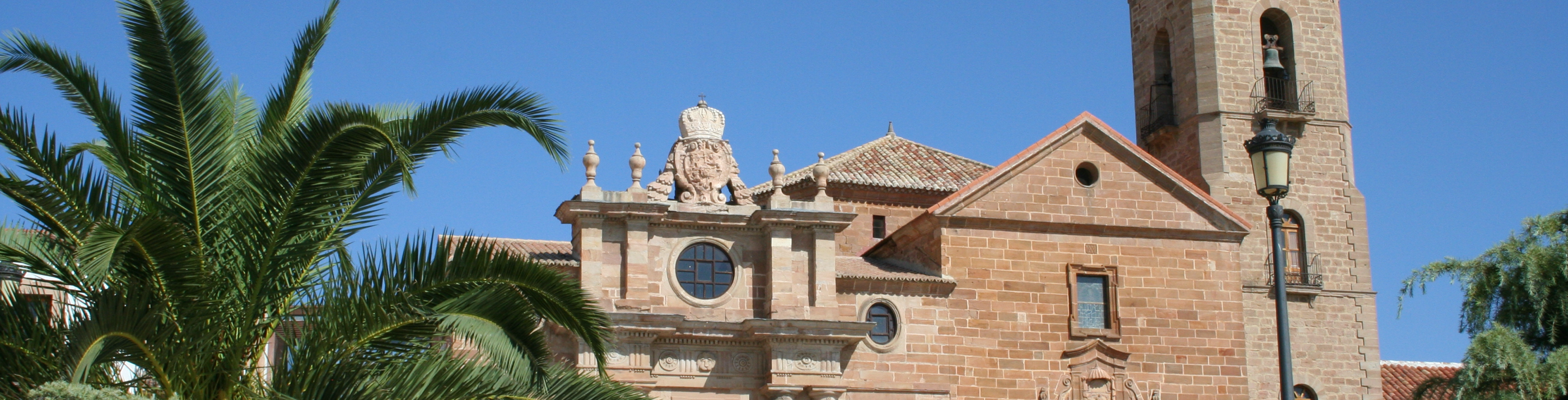
La Carolina
La Carolina, the town that eventually became the capital of the Nuevas Poblaciones, was born around a Carmelite convent called "La Peñuela", from which the town took its name until it was changed in honour of Carlos III. The convent, founded in 1573 and refounded in the 17th century, which included visits and stays by San Juan de la Cruz, was acquired by Pablo de Olavide to establish the headquarters of his Intendencia. La Carolina is considered to be the best and most complete example of Spanish town planning of the Enlightenment period. A grid plan, with large perspectives and axial axes, dotted with circular, rectangular and polygonal squares, incorporating all the resources and advances of Baroque and neoclassical town planning. In the capital of the New Towns, a whole urban scenography was created, with long and unlimited perspectives, or else converging in a singular architectural or urban element.
As the capital and seat of the superintendent, numerous works of public interest were erected: palace, church, council, prison, hospital, gardens. The rationality of the project is intensified by the stylistic uniformity of the façades of the houses, with front gardens which, due to their location, form a change of width and perspectives. In this urban setting, the variety and originality of the squares stand out. These include the octagonal square, the first to be built in Spain, the two elliptical squares surrounded by domestic architecture from the time of colonisation and the hexagonal square, used for bullfights.
The main axes that marked the foundation were: the one that runs from the Paseo del Molino de Viento, where the two monoliths of the foundation are located, to the Palacio del Intendente and the church; and the perpendicular to this, marked by the Plaza de las Delicias - Calle Madrid - Plaza del Ayuntamiento. The capital of La Carolina, in the New Towns as a whole, will have its repercussions from a productive and economic point of view. Olavide himself focused his efforts on making it one of the most industrious and active centres of the reign of Charles III. In 1775, there were cloth, silk, bathrobes and bargans factories, a chinaware factory, two hat factories, etc. This process was accompanied by a resurgence of mining activity in the area in the last quarter of the 18th century and reached its zenith in the first quarter of the 20th century.
Carboneros
Carboneros has one of the most interesting designs of the Nuevas Poblaciones, with the classic orthogonal layout, presided over by a singular elliptical square, formed by the incurvation of the main street. The square is dominated by the church and the granary. Carboneros has one of the most monumental churches in the Nuevas Poblaciones, with a magnificent ashlar façade, in the neoclassical style of the period. On either side are two houses for the civil and religious authorities. In front of the church is the granary which, with a simple doorway, closes off the other side of the square (this building has been refurbished and is now a public library). Several hamlets were created under Carboneros: El Acebuchar, La Mesa and Los Cuellos, whose purpose was to bring the peasant closer to his land. These villages were built on a pre-established layout based on the classicist precepts of symmetry and order. And if you ask the inhabitants of Carboneros about their surnames, they will be su ...
Carboneros has one of the most interesting designs of the Nuevas Poblaciones, with the classic orthogonal layout, presided over by a singular elliptical square, formed by the incurvation of the main street. The square is dominated by the church and the granary. Carboneros has one of the most monumental churches in the Nuevas Poblaciones, with a magnificent ashlar façade, in the neoclassical style of the period. On either side are two houses for the civil and religious authorities. In front of the church is the granary which, with a simple doorway, closes off the other side of the square (this building has been refurbished and is now a public library). Several hamlets were created under Carboneros: El Acebuchar, La Mesa and Los Cuellos, whose purpose was to bring the peasant closer to his land. These villages were built on a pre-established layout based on the classicist precepts of symmetry and order. And if you ask the inhabitants of Carboneros about their surnames, they will be su ...
Carboneros has one of the most interesting designs of the Nuevas Poblaciones, with the classic orthogonal layout, presided over by a singular elliptical square, formed by the incurvation of the main street. The square is dominated by the church and the granary. Carboneros has one of the most monumental churches in the Nuevas Poblaciones, with a magnificent ashlar façade, in the neoclassical style of the period. On either side are two houses for the civil and religious authorities. In front of the church is the granary which, with a simple doorway, closes off the other side of the square (this building has been refurbished and is now a public library). Several hamlets were created under Carboneros: El Acebuchar, La Mesa and Los Cuellos, whose purpose was to bring the peasant closer to his land. These villages were built on a pre-established layout based on the classicist precepts of symmetry and order. And if you ask the inhabitants of Carboneros about their surnames, they will be surprised by the numerous and varied names, corresponding to the first settlers and which still remain in this locality: Ahufinger, Yegler, Pringman, Cobler, Avi, Ibac, Filipp, Ming, Basmer, Nelf, Feter, Walter, Smit, Laud, Trunser, Cun, Divols, Grau, Risoto, Teclesmayer, Perger, Matiaces, Mesbailer, Sailer.
Guarromán
According to tradition, Pablo de Olavide had a predilection for this place, which he wanted to call Muzquía (in honour of Don Miguel Muzqui, who held the post of Secretary of State and universal office of the Treasury), but finally accepted the name "Río de los Granados", as it was known, giving one of its villages the surname of his wife Isabel, "de los Ríos" (Village of the Rivers). The choice of the site of Guarromán was motivated by the pre-existence on this road of the so-called Venta de Guarromán. Guarromán's town centre retains traces of the urban planning of the Enlightenment, a grid layout with blocks of houses arranged in geometric order. The most emblematic building, the church, dominates the urban layout, preceded by a large square, in which examples of the domestic architecture of the period are preserved. The Pósito de Labradores was built in 1789 by the master builders of the Nuevas Poblaciones, Silvestre Gómez and Jacinto de Garaña. With a square floor plan, it is divided into two naves by a central brick arcade, stabilised by wooden braces. It was refurbished in 1987 as a public library.
Numerous surnames inherited from the first settlers remain in this municipality, such as: Degen, Mitelbrun, Fischer, Gos, Smit, Nef, Wasmer, Laula. Others are preserved with some variants, such as Morher, which has become Moret, Amburg to Ambú, Eberle to Hervele, Mortiz to Morís, Bornich to Bornique, Klespies to Cleppi, Laub to Laup or Monblanc to Momblanc. In the case of Guarromán, the villages founded were: Aldea de los Ríos, Martín Malo and Aldea del Altico. Shortly afterwards, the village of Rumblar, known today as Zocueca, was added.
Arquillos
As well as getting to know one of the municipalities of the New Towns, Arquillos, considered the Gateway to the Condado, offers you the chance to visit the aforementioned region of Jaén. This town, which in the distance appears to be surrounded by olive trees, is another of the new towns with its varied, well-kept squares and its rectilinear layout. In the Plaza de la Inmaculada is the 18th century church and the town hall (located on the site of the old prison and commandant's house). The other square is the Plaza de Carlos III, where several buildings from the founding period are located, such as the 18th century Posada. Opposite is the Plaza del Reloj, with a haughty eighteenth-century tower that marks the passage of time unalterably.
Montizón
In the 18th century, this area of pastureland, known as "Barranco Ondo", was chosen to found one of the nuclei of the New Towns. As a result, the current urban and landscape configuration of Montizón bears the imprint of the Colonization villages founded in 1767, under the patronage of Carlos III and the direction of the intendant Pablo de Olavide, as part of the Nuevas Poblaciones programme. Montizón was created as the head of a parish with two hamlets: Aldeahermosa, about 3 km to the south, and Venta de Santos, 2 km to the north. In all three villages you can get to know the urban development of the Nuevas Poblaciones and enjoy the peace and quiet. Walking through Montizón, we can see that its town planning is based on a simple orthogonal grid, with rectilinear streets that form perfect square blocks of houses; the square is the main element, in which the 18th century church is located, which follows the model of the foundation.


