Natural Park of Despeñaperros and Nature Area of Cascada de la Cimbarra
Of impressive orography and great scenic beauty, this natural corridor has traditionally been the access to Andalusia from the Castilian plateau.
Despeñaperos, a gorge carved by a river of the same name into the slate rocks of Sierra Madroña, runs from northwest to southeast, breaking the uniformity of Sierra Morena with its rugged craggy shapes. The rocky walls, falling almost vertically, reveal the arrangement of the different strata. At the spot known as 'Los Órganos' ('The Organs'), some of the rocks are shaped like gigantic organ tubes.
Portuguese, holm and cork oaks (Quercus suber, Quercus ilex and Quercus faginea) constitute the most representative vegetal species of Despeñaperros. This autoctonous vegetation contrasts sharply with the green areas reforested with stone pines (Pinus pinea).
Among the typical animal species living in this protected Mediterranean scrubland habitat, the following occur in substantial populations: genets (Genetta genetta), beech martens (Martes foina), wildcats (Felis silvestris) and mongooses (Herpestes ichneumon). Wolves and lynxes (Lynx pardinus) have occasionally been spotted in the area. As in most of Sierra Morena, deer and boar hunting is a common sport activity.
Many different species of birds also live in the Natural Park of Despeñaperros: Spanish imperial eagles (Aquila adalberti), griffon vultures (Gyps fulvus), European serins (Serinus serinus), rock thrushes (Monticola) and wheatears (Oenanthe). The Valdeazores gully is of great tourist interest for its outstanding botanical diversity. One of the main cultural attractions of the area is the existence of major prehistoric Iberian sanctuaries, located in the 'Collado de los Jardines' ('Gardens' Pass'). Human presence in this natural space dates back to the Neolithic period. The archeological remains found in the 'Cueva de los Muñecos' ('Dolls' Cave'), one the major sanctuaries in Spain, date back to this period. The rock paintings found in the 'Cuevas de las Vacas del Retamoso' ('Cave of the Retamoso Cows') are also of great artistic and historical value.
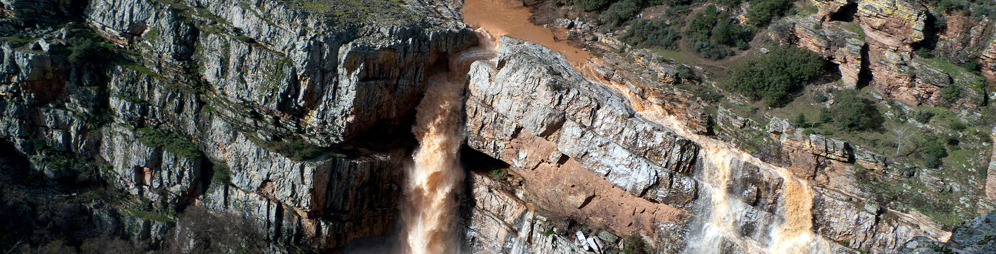
Outside the limits of the Natural Park, very near the village of Aldeaquemada, the river Guarriza suddenly turns into a spectacular waterfall calleed 'La Cimbarra'. The whole area, comprising 534 ha. (1319 ac.), has been declared a Nature Reserve. Near the Cimbarra Waterfall, we find a whole group of important caves and shelters with Levantine and Schematic Rock Art on their walls that were declared a World Heritage Site by UNESCO in 1998: 'Tabla del Pochico', 'Poyos de la Cimbarra', 'Garganta de la Hoz'...
Information links