


Cycling route Río Madera - Valle de Los Anchos
The route starts at the crossroads in the village of Río Madera, at the intersection of the JF-7038 with the JF-7039. First, ride towards the village on an asphalted road, past the mountain guesthouse and small village chapel on the right and a few meters further along, on the left, the old wash-house and the Rocanales farmhouse.

NAME OF THE TRAIL
CIRCULAR RÍO MADERA VALLE DE LOS ANCHOS
TYPE OF TRAIL
Circular
START POINT
Junction of Río Madera on the JF-7038 with the JF-7039
HEIGHT
1178 m
ARRIVAL POINT
Junction of Río Madera on the JF-7038 with the JF-7039
HEIGHT
1178 m
TOTAL DISTANCE (IN KILOMETERS)
23290
Asphalt or cement section % of total 19%
Section of track or forest road or promenade % of total 71%
Senda section % of the total %
Sections of livestock track. Green way % of the total %
Type of firm
Sandy and rocky
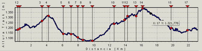
SLOPE
788 m
810 m
DIFFICULTY. ASSESSMENT ACCORDING TO METHOD MEASURE
0
MEDIO.
Severity of the natural environment
0
Itinerary
Orientation in the itinerary
0
Displacement
Difficulty moving
0
EFFORT.
Amount of effort required
TYPE OF CARTOGRAPHY
Topographic maps of ANDALUCÍA DE IGN (1: 25.000): SHEET 22
PASSAGE PLACES (IN ORDER TO THE DIRECTION OF TRAVEL)
Aldea Río madera
30S x=533331 y=4233306
1183
Cortijos de Rocanales
30S x=533133 y=4233197
1192
Cortijos del Jaral
30S x=532253 y=4231745
1267
Cortijos Collado de los Asperones
30S x=531760 y=4231172
1317
Cortijos de Romaguillo
30S x=532816 y=4230536
1140
Camping Garrotegordo
30S x=533555 y=4230113
1137
Casa forestal Laguna
30S x=533675 y=4229301
1107
Venta del Pescador
30S x=533512 y=4228707
1080
Venta de Rampias
30S x=533966 y=4227921
1073
Cortijos de la Hoya del Azor
30S x=535589 y=4229787
1238
Ecomuseo etnológico Alma Serrana
30S x=536505 y=4230648
1276
Aldea de los Anchos
30S x=536614 y=4230936
1314
Aldea de Pradomaguillo
30S x=537218 y=4231536
1315
Collado de Pradopuerco
30S x=536652 y=4231569
1389
Ruinas Molino de las Tres Aguas
30S x=535231 y=4233157
1198
Vado de Río Madera
30S x=533963 y=4232619
1169
Campamento La Morringa
30S x=533861 y=4232612
1176
HEIGHT PROFILE
MUNICIPAL TERMS BY WHICH IT RUNS
Segura de la Sierra Santiago Pontones Sierra de SeguraRECREATIONAL OR SPORTS AREAS NEAR THE TRAIL
La Morringa
DESCRIPTION
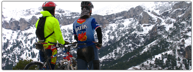
The tour begins at the junction of the village of Río Madera, at the intersection of the JF-7038 with the JF-7039, initially we go towards the village, by paved road, leaving on our right the mountain inn and the small hermitage of the village and a few meters to the left the old washhouse and the Rocanales farmhouse.
After 1.7 km we leave the asphalt road, to turn left along a forest track and between pine forests, descending slightly to the stream and from there gradually going up the Arroyo de los Asperones and leaving the Cortijos del Jaral on the right , until reaching the Collado de los Asperones where a small Segureña sheep farm is located.
From there and in a vertiginous descent along the Arroyo de Romaguillo we descend to the farmhouses of the same name where we return to the paved road. Once in this we turn right to continue downstream through the Río Madera valley, leaving farmhouses on both sides of it that show the most ancestral way of life of these mountains, where the locals won small plots next to the houses to have small self-supply gardens. We will travel 3.7 km down the road until we reach the small village of Venta de Rampias, just when we cross a bridge on it, a narrow asphalt track opens to our left and is signposted as Los Anchos.
The Los Anchos track, in a smooth and continuous climb, runs first along the right bank of the valley, leaving farmhouses like Hoya del Azor on the left, and once we cross to the left side we will find the Cortijos de Majada Oscura on our left in where an ethnographic museum is located that is well worth a careful visit.
The laricio forests dotted with some deciduous trees, poplars and fruit trees dot these places along with rocky walls especially on the right side of the valley. Continuing our ascent through the same, we arrive at the two most important villages of the same, it is the village of Los Anchos and Pradomaguillo, places that deserve a short break to stroll through its narrow streets.
At the entrance of Pradomaguillo we must turn left following the GR 147 signs, but it is well worth getting off the bike and looking 150 m past Pradomaguillo, to contemplate from the track that continues through this valley, in a true natural viewpoint, the Valley of the Anchos in all its splendor.
Just 400 m further on, on the GR 147, we find a small hill on our left devoid of trees. You have to climb up to it because we will contemplate great panoramic views of the valley and the Calar that rises before us with its limestone walls. Later we continue our dirt track to crown at just 300-400 m by the Collado de Pradopuerco and once crowned simply follow the busiest track, in a sinuous but gentle descent. We will contemplate, mixed with the slender black pines, some small holly grove and, above all, large pastures under the trees. To our right the Arroyo de las Tres Aguas and a vertical mass of limestone rock that is the Calar de Peñarrubia; just when we are in front of the Calar, down near the stream we find some ruins on a clearing that belong to an old flour mill. After just 200-300 m, we will leave the GR 147 to the right to continue the track on which we were traveling in front. Soon this track descends and we cross the Tres Aguas stream that a few meters away flows into Río Madera. Once we have crossed the stream we find a steep slope, a hill and a descent to ford the Madera River.
Cruzado Río Madera, we are in a very fresh and leafy area, here is located the Controlled Camping area of ??Morringa with its recreational area, it is worth taking a 100 m detour to the right to contemplate the backwaters of the River and the facilities of the area .
We come back to the paved road, which we must continue to the right, to continue climbing through the Río Madera valley. At 1.2 km we reach our starting point.
Follow us #JaénParaísoInterior


