


Cycling route: Mirabuenos - Los Centenares
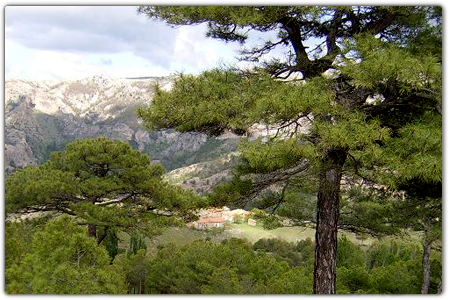
The route starts on the trail to Cuesta de Mirabueno, on the Llanos de Arance track, and consists of one linear section (there and back) and one circular section. The route starts at 4.6 km on the A-319 road, on a closed track on your right. The track climbs up through the three types of pine found in the Nature Reserve (Aleppo pine, Coriscan pine and European black pine) as you gain altitude. Half-way up you also go through a forest of magnificent ilexes.

NAME OF THE TRAIL
CAMINO DE MIRABUENO A LOS CENTENARES
TYPE OF TRAIL
Lineal y circular
START POINT
From the A319 we take the detour to Llanos de Arance and continue the JF-7099 entrance track to the Camping. Our route will begin at the second track that we find on the right.
HEIGHT
681 m
ARRIVAL POINT
Aldea de Los Centenares
HEIGHT
1171 m
TOTAL DISTANCE (IN KILOMETERS)
42100
Asphalt or cement section % del total 0 %
Section of track or forest road or promenade % del total 100 %
Senda section % del total %
Sections of livestock track. Green way % del total %
Type of firm
Arenoso y rocoso
SLOPE
1938 m
1941 m
DIFFICULTY. ASSESSMENT ACCORDING TO METHOD MEASURE
0
MEDIO.
Severity of the natural environment
0
Itinerary
Orientation in the itinerary
0
Displacement
Difficulty moving
0
EFFORT.
Amount of effort required
TYPE OF CARTOGRAPHY
Mapas topográficos de JAÉN (1:10.000): 908 13; 908 23; 908 12; 908 22
PASSAGE PLACES (IN ORDER TO THE DIRECTION OF TRAVEL)
Inicio Camino de la Cuesta de Mirabueno
30S x=516361 y=4213744
692
Fuente del Roble. Tornajos
30S x=519393 y=4213635
1245
Camino a los Archites y Puente de Hierro
30S x=519459 y=4213736
1233
Antiguo Comedero de Buitres
30S x=519335 y=4213317
1303
Subida a Majal Alto- Vistas panorámicas
30S x=520033 y=4212845
1456
Las Canalejas
30S x=522110 y=4214368
1355
Los Centenares
30S x=522983 y=4214142
1386
Los Archites
30S x=521101 y=4215709
1016
Puente de Hierro
30S x=520998 y=4218025
686
Mirador de Mirabueno
30S =516047 y=4214438
638
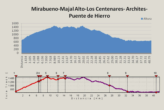
HEIGHT PROFILE
MUNICIPAL TERMS BY WHICH IT RUNS
Santiago Pontones Sierra de SeguraRECREATIONAL OR SPORTS AREAS NEAR THE TRAIL
Llanos de arance.
DESCRIPTION
The route begins on the Cuesta de Mirabueno road, on the Llanos de Arance track, and has a linear round-trip section and a circular section. The route begins 4.6 km from the A-319 road, right on a closed track on our right. This track, in continuous ascent, takes us through the three types of pine forests that exist in the Park (Aleppo, Negral and Laricio pines) as we gain altitude, but we must highlight the magnificent oak forest that we cross halfway up.
We will be able to refresh ourselves in the Fuente del Roble, which gives its name to the initial area, and at the crossroads of the road to the Archites, at km. 6.7, we will have to turn to the right at first to do a round trip. Later, when we return, we will continue our route along the path to the left. The linear section has great attractions, such as an old vulture trough located at km 7.2, or the Majal Alto guardhouse with impressive views of the entire Banderillas massif and the Guadalquivir Valley (km 9.1 ). Once Majal Alto is crowned and after a brief descent we will continue ascending to reach first the village of Las Canalejas and then Los Centenares, two of the towns that were left uninhabited with the creation of the National Reserve of Cazorla y Segura in 1960.
From Los Centenares we started the return by the same way until we reached km 4.6, where we took the track of the Archites, another of the farmhouses inhabited in their day, where they also took advantage of the closest lands to cultivate all kinds of cereals, and which are now mostly forest land.
Finally, continuing the track in continuous descent we reach the edge of the Tranco Reservoir, just in front of the Island of Cabeza de la Viña, in the place known as Puente de Hierro. We turn left there to skirt the level of the reservoir. We will leave on our right the ruins of the Bujaraiza castle and the plain of the same name, well known as the scene of the bellowing, the combats that take place every year in September between male deer in their mating season. Finally we arrive at the Mirabueno viewpoint on the Guadalquivir River and just 300 m from the starting point.
Follow us #JaénParaísoInterior


