


Puerto de Tíscar
Singular places
, Cazorla
, Quesada
Puerto de Tíscar, or the Tíscar Pass, is not merely a mountainous obstacle you must traverse on your way to visiting the church of Santuario de Nuestra Señora de Tíscar, the historical patron of the Settlement of Cazorla and one of the most iconic religious symbols in these mountains; it is a rugged landscape feature, with spectacular views and an excellent place to observe Spanish ibex: in short, a spot of major historical and natural significance. Leaving your vehicle in the car park at the pass itself, take a short stroll around the Atalaya del Infante Don Enrique, a medieval watchtower dating back to the 14th century which boasts spectacular and absolutely unmissable views.
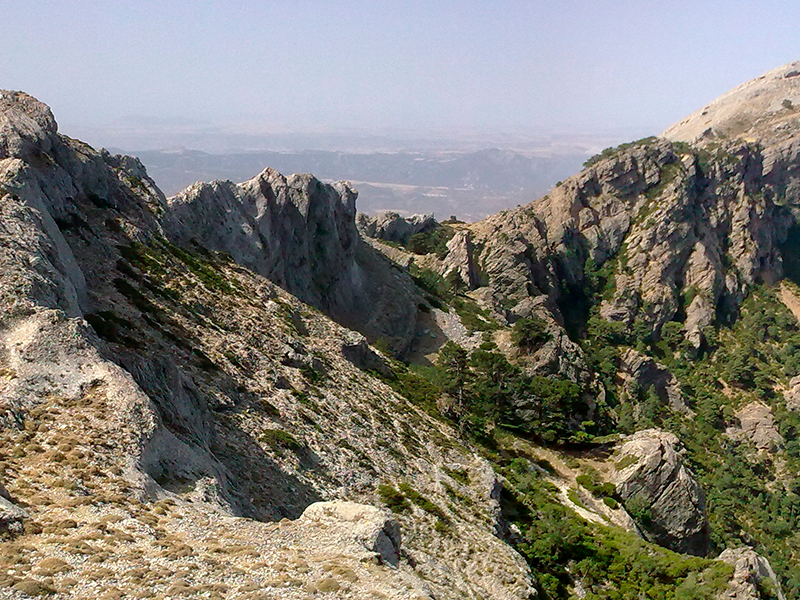
From the watchtower you can feast your eyes on a series of panoramas which will give you a greater insight into the surrounding area: towards the south there is a large ravine, also called the Tíscar, which links the hill with the steppe-like valley of the Lower Guadiana; at its end, the ravine narrows to a rocky arch on which the Moors built the fort of Castillo de Peña Negra. When the Moors were expelled from the area, the new occupiers of this land built the church of Santuario de Tíscar over the walls of the old fort. Looking west you can see Peña de las Carboneras, one of the mountains in the smallest and most charming landform in the whole massif: namely the Quesada mountain range, which is home to numerous examples of prehistoric rock art that have been declared World Heritage sites.
To the north you are greeted with the sight of the Jaén countryside and its olive groves, which stretch as far as the eye can see and, like waves during a storm, appear to surge aggressively up the slopes of the Cazorla mountains, which can clearly be seen to the right of the olive groves. Looking eastwards your eyes will inevitably be drawn to Picón del Rayal, which at 1834 metres is the first major mountain of the southern section of the Cazorla range and an impressive mass of limestone with a vertical crack in its north face. The place name “Rayal” was a synonym for “frontier” during the Middle Ages, and the aforementioned watchtower is a reminder that this area marked the border with the Nasrid kingdom of Granada for almost three centuries.
We recommend…
- Bringing your binoculars and sweeping them across the limestone crags found in the most part towards the northwest of the area, as you are very likely to spot Spanish ibex. It is also a good place from which to observe birds of prey in flight.
- Next to the pass itself is the spring of Fuente de las Carbonaras, an ideal place for a refreshing stop. If the spout is dry, as is often the case in summer, follow the path leading away from the spring across the flat ground and you will reach the Las Carboneras Forest House, behind which there is another spring.
LOCATION
Puerto de Tíscar is the highest point on the A-6206, the serpentine mountain road which links Quesada with the two southernmost towns in the park, namely Pozo Alcón and Hinojares. To reach this attractive hill from Quesada, continue straight ahead as you leave the town, ignoring the turn-off for Huesa (there is a sign indicating Puerto de Tíscar) and carry on for a further 8.5 kilometres or so until the road levels out. Here you will see a signpost for the pass, which also gives the altitude. From Hinojares (18 kilometres away) and Pozo Alcón (23 kilometres away), travel along the A-6206 in the opposite direction to that described above, i.e. always follow the directions for Quesada at each crossroads.
Follow us #JaénParaísoInterior


