


Cumbre el Yelmo
Singular places
, Segura de la Sierra
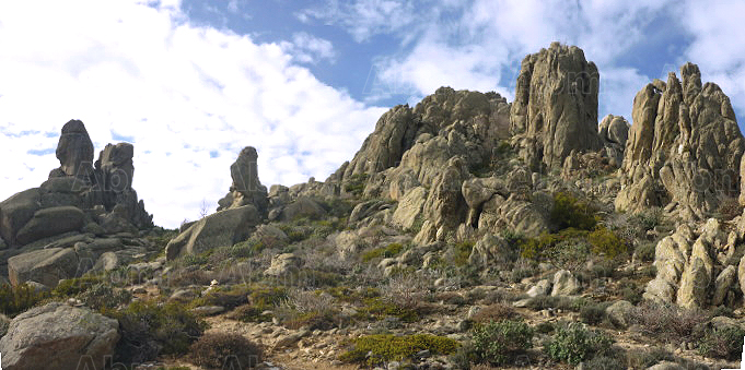
El Yelmo is the most popular and iconic mountain in the northern section of the park owing to the stunning views it boasts from its peak, which rises to an altitude of 1,809 metres. This eyrie offers an unrivalled view of the immense forests across the whole park, the distant mountain peaks in the province of Albacete and the wide plains of Castilla-La Mancha. A particular highlight is the bird’s-eye view of the picturesque towns of Hornos de Segura and Segura de la Sierra, amidst a harmonious lowland setting of forests and olive groves, along with the waters of the Tranco reservoir. El Yelmo is also an internationally renowned location for hang-gliding, with a launch point that boasts the ideal conditions for practising this sport.
The slopes of the mountain are covered with dense pine forests dotted with the occasional oak tree, and in certain areas a mixed woodland that is home to both species. Gall oaks are also abundant, while in some places you may be lucky enough to come across beautiful maples. Spanish ibex can often be spotted at the peak of El Yelmo, while the only vegetation found at such an altitude is broom and a few small, twisted Corsican pines.
El Yelmo is also the focal point for the International Air Festival, a unique event which brings together thousands of different people - ranging from the inhabitants of local villages to sportspeople from all over the world - to take part in a range of different activities.
The peak is accessible by car via a narrow, asphalted forest track which can be reached from the village of Robledo, near Cortijos Nuevos. However, we recommend that you at least ascend the last few kilometres on foot, as you will be able to appreciate the beauty and purity of your surroundings so much more.
El Yelmo can also be accessed from the opposite side via the Campillo natural beauty spot, which is situated next to the JF-7016. This route, which takes the form of an asphalted track, will take you to a higher point than the other, although we recommend ascending on foot via the trail signposted PR-A 194, which is 3 kilometres long and takes around 1 hour and 20 minutes to complete.
Follow us #JaénParaísoInterior


